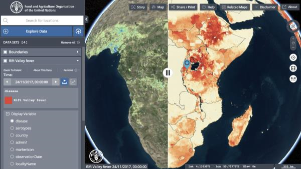
21 July, Rome - The Food and Agriculture Organization of the United Nations (FAO) today launched the Hand-in-Hand geospatial platform with a large and rich set of data on food, agriculture, socioeconomics, and natural resources to help strengthen evidence-based decision-making in the food and agriculture sectors.
The platform is a crucial tool for all efforts to build back better and create more resilient food systems post COVID-19.
It boasts over one million geospatial layers and thousands of statistics series with over 4,000 metadata records, bringing together geographic information and statistical data on over ten domains linked to food and agriculture - from food security, crops, soil, land, water, climate, fisheries, livestock to forestry. It also includes information on COVID-19's impact on food and agriculture.
The data has been sourced from FAO and other leading public data providers across the UN and NGOs, academia, private sector and space agencies. It also incorporates FAOSTAT data on food and agriculture for FAO's 194 member countries plus 51 territories, from 1961 to the most recent year available.
"Geospatial technologies and agricultural data represent an opportunity to find new ways of reducing hunger and poverty through more accessible and integrated data-driven solutions," said FAO Director-General, QU Dongyu.
"The Geospatial Platform serves as a digital public good to create interactive data maps, analyze trends and identify real-time gaps and opportunities," added the FAO chief.
The platform can be used by anyone and its application will in turn help data-driven and evidence-based decision-making in food and agriculture.
Amongst its many uses, the platform provides vital information to:
"The geospatial platform will allow us to design more targeted agricultural interventions and investment plans through a territorial approach - an approach that fosters equality, inclusion and sustainable food and nutrition security," said FAO's Chief Economist Maximo Torero.
FAO will add new datasets and country- and domain-specific case studies to the platform to improve targeting and tailoring of policy interventions, innovation, finance and investment, and institutional reform in food and agriculture.
The platform is part of FAO's Hand-in-Hand initiative - an evidence-based, country-led and country-owned initiative aimed at accelerating agricultural transformation and sustainable rural development to eradicate poverty (SDG1) and end hunger and all forms of malnutrition (SDG2), including through the use of the most sophisticated tools available such as advanced geo-spatial modeling and analytics.